


 Left camp at 4am, and we’re excited about our adventure. Arriving at the tour office we found that we have a private tour today. (Yeah) About 5am we hopped into the van with our guide Aaron and headed north up the Steese Highway (Alaska 2). Fairbanks is broken into boroughs and we are driving through North Star which is the size of Delaware! At the community of Fox we stayed northeast and turned onto Elliot Highway. As we traveled along there were tailings from the old mining days. These are piles of dirt left after going through the sluice. We passed the “Sniper Mine” which is a mom and pop operation. The mine got it’s name when they started shooting at folks on the road with rifles and closed the road for a while which affected locals and tour operators. The state troopers and police soon resolved the issue.
Black and White Spruce line the south side of the road while the north is covered in permafrost and only Black Spruce. Black Spruce is the only tree that will grow in permafrost and is very stunted. We also learned Black Spruce needs fire in order to reproduce. Interspersed on the south side are groves of White Birch which grow where the melt water comes down the mountains to melt the permafrost. You can see lines on the mountains of light green foliage that tells where the water is. The Elliot Highway winds around the base of Wickersham Dome. From the base the road begins to climb to 3,270 feet and we are in the clouds with partial views of the White Mountains which are white limestone, although we can’t see the peaks today. Wickersham is a popular hiking area. As we descend we see Grapefruit Rocks ahead which are 2 large outcrops popular with climbers. Soon we see the Alaska Pipeline to our Northwest, as it snakes along the mountain sides.
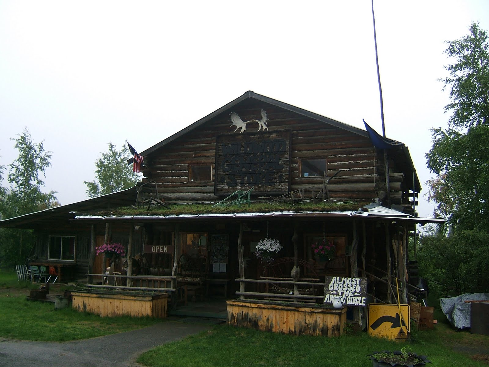
Our 1st stop is Joy, Alaska. Joy has a population of about 30 people. It was homesteaded by Dick & Joy Griffin who received 160 acres. They had to improve the land and after 2 years it was theirs. The Griffins raised goats and eventually met another family who also raised goats. They soon became friends. The Griffins sold off acres to the Carlson’s and a community was born. The Carlson’s settled on the land raising 5 kids of their own and 18 adopted children from all different countries and cultures. Joe Carlson met us at the door of what is now the Arctic Circle Trading Post. Over coffee and coffee rolls Joe told us stories about the family and what they are doing now. It seems like it all started when the kids began to sell Lemonade in the 1970‘s. They dug a hole in the permafrost to keep the Lemonade cold and sold it to truckers for $5 a glass! The Carlson’s saw a need for a trading post and the rest is history. We spent about half an hour with Joe, and could have spent a lot more, but we had to move on. The town of Joy is named for Joy Griffin.
Back on the Elliott Highway we descend the slopes into Bridge Creek Valley. We cross the Tolovana River Bridge and wind our way around Amy Dome, 2,317 ft, while we parallel the river to our southwest through the valley. Rolling through the old mining town of Livengood (population 25) we arrive at the junction of the Dalton Highway. The pavement ends here and the hills are created by silt building up and pushing the ground upwards - not by glaciers. We learned permafrost is earth that has been frozen for 2 years and 80% of the state is covered with this silt permafrost.
We are now driving on the Dalton Highway. This is known by several names, “Haul Road” and “Ice Road” in the winter. If you watch the TV show ‘Ice Road Truckers’ this is the road they drive. The road is 415 miles long and meanders through absolutely magnificient remote wilderness all the way to the Arctic Ocean! The road follows the Alaska Pipeline up and down hills and through tundra, forested valleys and the Brooks Mountain Range. In places the pipeline will disappear below ground, where it goes through mountains only to reappear later.
The 2nd stop was Yukon Camp at the Yukon River crossing. It’s about 10am so we stopped and had breakfast. On the wall of the camp were pictures of a Grizzly Bear breakin. After closing up for the winter the owner got a call one morning, telling him a window was broken. Upon arriving at the camp the owner found the place was “trashed”. Cautiously entering the building they found a mother grizzly and cub curled up in a corner. They had pulled T-shirts and other materials off the shelves and made themselves at home. They were able to chase the mom and baby out of the building. Thinking that was it, the owner heard a noise in the rear of the building near the kitchen. Walking toward the back hall he discovered a very large male grizzly which was ready to attack. The encounter ended poorly for the bear. We could not believe the amount of destruction these animals made!
Leaving the camp we cross the Yukon River Bridge. This is a 2,290 ft wooden deck bridge. Driving north we enter a Boreal Forest also known as Taiga. This is the world’s largest Boreal Forest and covers most of inland Canada & Alaska as well as parts of the far northern continental U.S from Minnesota to New Hampshire & Maine. Across Eurasia most of Sweden, Finland, inland Norway, much of Russia, Mongolia, and northern Japan are also part of the Taiga. Rolling along we enjoy unbelievable panoramic views where the vast wilderness is mind blowing! The road starts to wind as it climbs up and down hills with steep grades and grassy slopes on both sides. Soon we reached the top of a hill and find ourselves looking down the “roller coaster”. A steep descent of about 10% followed by an immediate ascent of 10%… what fun! I can’t imagine doing this in the ice & snow with a huge truck - eh.
Along the way we stopped in a pull off to get an up close look at the pipeline and its truly amazing structure. The sun has broken through now and we can see a rock formation ahead called Finger Rock. The vegetation changes again. We are crossing areas of moist tundra for the next few miles. A quick stop allowed us to walk on the spongy permafrost. It’s really bouncy. We could reach down into holes in the permafrost where the top ground had melted but could feel the hard ice only inches below.
Back on the road the van pulls over to the side of the road several times to allow huge tractor trailers pass us carrying huge loads of materials and generators. We stopped at the Finger Mountain Overlook for a break. The rocks are part of a volcano that pushed through the permafrost to the surface. We watched the tundra for Bears and Caribou, but no luck today.
We are almost to our destination as we cross the Kanuti River. Soon we turned onto a small road to the left and we arrived at the Arctic Circle - Latitude 66.33. The sun doesn’t set on summer solstice and doesn’t rise on winter solstice. A third of Alaska lies within the Arctic Circle, the only true polar region in the state. Aaron surpised us with quite a celebration. He rolled out the red carpet and played his trombone as we officially stepped over the Arctic Circle. Sitting at a near by picnic table we celebrated with arctic mud (chocolate cake) and perma frosting….However the mosquitoes were really bad so we hurried back to the van.
Going north we begin a steep and winding ascent to “top of the world views” way above the tree line. We can see the magnificent Brook Mountain Range in the distance as we stop at a pull off. Just before reaching Coldfoot Camp we saw 2 moose lounging in a pond to our left. Believe it or not these are the only animals, other than rabbits, we’ve seen all day.
We’ve covered 250 miles today as we pull into Coldfoot (population 13). The van parked in front of the Truckers Café known as the northern most truck stop. Coldfoot is a jump-off point for flights into Gates of the Arctic National Park. We spent time in the Arctic Visitor Center looking at exhibits and talking to the rangers. We have been on the road 12 hours and it was a fantastic trip. It’s another 250 miles to Deadhorse and the Arctic Ocean, but we will be heading home. We said good-bye to Aaron at the airport and piled into our little airplane. Taking off we flew back over the mountains and river with fantastic aereal views. An hour later we were back in Fairbanks.
It was a great day and a phenomenal trip, but we’re tired and soon it’s time for bed!
Pictures: Joy Trading Post, Carlson's Lemonade Stand, Dalton Hwy & Pipeline, The Roller Coaster, Dalton Hwy, Top of the world view, Finger Rock Tundra, Kanuti Valley (3), Arctic Circle (2), Brooks Mountain View, Coldfoot Truck Stop, Our Ride Home, Mountain view from plane, Yukon River from plane.
No comments:
Post a Comment