

 Nice day and typical in the low 50’s with some showers. Today is exploration day. Yesterday we stopped at the US Forest Service office and they gave us a map of the forest service roads so we could explore the back country.
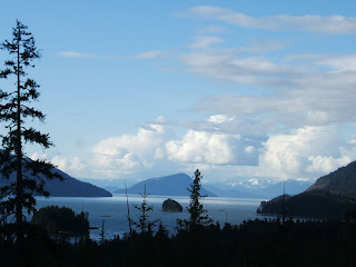
Out of camp we turned right onto Zirmovia Hwy and edged along the Zirmovia Straight with it’s shimmering blue water. We checked out the Shoemaker Bay Recreation Area - it’s nice and right on the water, but we like where we are. Further down the highway becomes forest service land. We stopped at every camp site with overlooks and they were amazing! Boardwalks take you down a path to an opening with picnic table, fire pit, toilet, and a covered fire wood supply. You can easily spend a day or two at these places. If you are looking to boondock Yunshookun Loop had fantastic campsites (no services). We took pictures at many of the overlooks like 3 Sisters, Anita Bay and the clouds cleared enough to see Devils Thumb!
We are sauntering through thick forest of Cedar, Douglas Fir, and Spruce with good but narrow gravel roads which are very curvy in places. We turned onto Road 6267 running along the straight and followed it to Nemo Point. There were 2 beautiful black tail deer watching us come down the road. We watched each other for a while then we continued on. There are many hiking trails off these roads. We crossed a little wooden bridge over the crystal clear Upper Salimander River and then turned onto Road 6265. We came to the Lower Salimander where we pulled in to take a break. There were three locals fishing and they were sitting around a small campfire. One guy with a long beard had a pistol almost bigger than he was. We checked out the river and then decided to move on.
We are about 30 miles into the back country now. The terrain is really rough but this is the real wilderness. On our right was road 50040 leading to Highbush Lake. About 2 miles in from the road was a trailhead. We took the narrow board steps down through the muskeg to the lake. It was just pristine! There was a USFS skiff, but we didn’t know if we could use it, so we went back to the car. (Later we found out we could have used the boat - oh well..).
Back on Road 6265 we went up and down hills where we couldn't see the road in front of us and then 'wow' there would be another fantastic view. We drove to the end and arrived in Earl West Cove on the north side of Wrangell Island. The cove is another magnificent place. Soon we heard a car, it was the 3 locals we met before. We talked with the lady and found she was a Native and she told us a little about the area. The guys fished for a while and Ken decided to throw a line in too. No luck today…. It was time to head back. Our final stop was Pats Lake off Zirmovia Highway. It was more like a little pond than a lake.
Back at camp we had dinner, talked about the day, and went to bed.
Pictures: (left to right) Road to Nemo Point, Nemo Point Rec Area, Eagle on the back road, Devils Thumb, Boardwalk to 3 Sisters Overlook, 3 Sisters Overlook, Anita Bay Overlook, Road 6267, Muskeg Meadow, Trail to Highbush Lake, Highbush Lake, Earl West Cove, Lower Salamander River, Road 6265

No comments:
Post a Comment