Monday, May 31, 2010

Gateway To The Interior


Another gorgeous sunny morning as we headed into town for breakfast at the Bamboo Room. It’s a little local place and the food was good. We’re excited as we leave Oceanside and stop at the Duck In RV and Car Wash just outside of town. With both vehicles clean and gassed up we hit the road at 10:30am.

Driving the Haines Highway, one of North America’s most scenic highways, we enter the Chilkat Bald Eagle Preserve. The preserve was established in 1982, and the 48,000 acres is the seasonal home to more than 3,000 bald eagles. We’ve seen several eagles and one nest along the river. The eagles return to the same nest every year and add to them. Some nests can be up to 7 feet across. They have their fledglings in April.

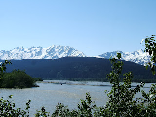
The road parallels the glacial silt green Chilkat River with magnificent views of the Takhinsa Mountains across the river to our southwest. We stopped at a viewing area to walk the river flats looking for eagles. On the way back we met some folks who were viewing Mountain Goats up on a high mountain ridge across the road with a scope. The let us look and we could see 7 Mountain Goats with babies.

The Chilkat River turned east and we followed the Klehini River northward passing the Saksaia and Jarvis Glaciers on our left. The scenery is fantastic and that’s what we’ll see the most of today!

Arriving at Pleasant Camp, Canadian customs, we had no problems, but we had to ‘abandon’ the personal pepper spray we had on board. The officer explained we could carry bear spray and cross the border. We are in British Columbia now and after crossing 5 Mile Creek we start to climb into a glacial area and the landscape changes from river valleys and forest to glacial alpine tundra with spectacular snow covered mountains. With the elevation rising we arrive at the south end of Three Guardsman Lake which is breath-taking. Three Guardsman Mountain (6300 ft) rises directly behind the lake. We kept saying - how do we describe this! - we can’t. We descend only to start another climb. Crossing Stonehouse Creek we can see the highway rising in front of us. Reaching the top of Chilkat Pass (3439 ft), its very windy, and everything is covered in snow and sparkles in the sunlight.

We stopped at Historic Milepost 48 at a gorgeous turnout on the Haines Highway Summit (3510 ft) and read the history of the highway. Part of the highway was originally a ’grease trail’ used by the coastal Chilkat Indians trading oil for furs from the Interior. In the 1880’s Jack Dalton, explorer and entrepreneur, developed a packhorse trail to the Klondike goldfields along the old trading route. The present road was built in 1943.

The highway travels between the sapphire blue Twin Lakes (one on each side of the highway) and enters the Tatshenshini-Alesk Wilderness Provincial Park where we stopped in a large pullout for lunch. The ice fields visible to the west are the largest in the world outside the polar ice caps. We are high on a hill looking down over the Tatshenshini River valley and alpine tundra. This is definitely grizzly country. The river is a big rafting area in the summer, but we can still see snowmobile tracks in the snow running up and down the foothills. There was a car at the end of the pullout with what looked like the hood up, so Ken strolled over to see if the man needed help. Nope it was the “Grizzly Man”. He’s local and comes up here to track and locate bear to hunt. He had all his gear and weapons in his little car. He told Ken he hikes miles into the woods and along the river and has already caught 2 bear this year. Ken found him very interesting. Once Ken came back to the coach we had lunch just watching nature!

After lunch we continued on and came to the Yukon border in Canada. This was exciting - we never dreamed we would be in the Yukon. We laughed remembering the 50’s TV show when we were kids 'Sergeant Preston of the Yukon'.

We are in the Kluane National Park now with the majestic St Elias Mountains on our left. As we ambled down the highway Ken saw two moose in a marsh. Along the way we passed the turnoff for the Klukshu Fish Camp. We kept going as we weren't sure how good the dirt road was down to the camp. This is the last working Fish Camp Klukshu left from the gold rush days. There are wooden fish traps and smoke houses. Members of the village still work this village every summer.

Our stop for today is Lake Dezadeash (Dezi-ash) Yukon Government Park. We found a site right on a point on the lakeshore. It's beautiful and breezy which keeps the bugs down. Hoping to put the boat in we checked the boat ramp, but it's too windy and rough with lots of white caps. A nice beach is directly behind the site and we put our chairs out and enjoyed the views and lapping waves on the lake. There is no one here and its great. Ken spotted 2 white forms across the lake, with the binoculars we could see they were Trumpeter Swans! They were gorgeous and huge!

When the sun went in it got cold and very windy. We didn't have a fire - to dry and no rain. We had dinner, played Scrabble and went to bed listening to the wind and waves on the lake.

Great day!

Pictures:Chilkat River Flats (2), Chilkat Eagle Preserve, Saksaia Glacier, 3 Guardsman Mountains (2), Climbing Chilkat Pass, Chilkat Pass Summit, Entering the Yukon, Tatshenshini River Valley lunch spot,1st View of Lake Dezadeash, Our site on Lake Dezadeash, Relaxing lake view

Sunday, May 30, 2010

Revisiting Favorite Places

Another gorgeous day. We had a leisurely breakfast and sat outside watching almost all of the other RV's leave. Some are heading inland like we will be and others to the ferry to go home.... We feel bad for them!

Ken read while I did more route planning. Later we decided to drive out to Chilkoot State Park again. Sitting at the lake Ken threw a line in - nothing. Then we drove back through town and down Mud Bay Road to Chilkat Inlet. While we were out there a couple days ago we saw a pipe with mountain water running out of it for drinking. We filled up our water jugs and drinking cups and then headed home. Of course we checked out every side road we could find... most led to nowhere.

We watched TV and talked with Joyce for a while. Tomorrow we are on the road.

Saturday, May 29, 2010

Hanging in Haines

Today we're getting ready for the road. We spent some time talking to our neighbor Linda and then went to get groceries. Ken went for a stroll and ended up helping Kerry (owner's husband) put up a large tent. They have BBQ's in it a couple times a week in the summer.

Let me tell you about Oceanside RV Park. If you are coming to Haines this is the place to stay! It's not a big fancy place, with gravel sites and side by side sites - BUT - the views of the Lynn Canal and Chilkoot Mountains are stupendous. Picnic tables and fire rings perch along the edge of Portage Cove looking over the canal. The cruise ships and ferrys go by us and when the cruisers stop in Haines we can watch from our site. The park is walking distance to everything. The other parks are out of town and you definitely need a car to get around. We loved the park and would definitely go back again.

I spent the day reading the Milepost, routing the 1st leg of our road trip, finding campsite options and identifying things to do and see.

We stored our winter jackets and heavy clothes under the bed and got out the lighter things. The temperatures are warmer inland than in the Inside Passage.

We had dinner and sat outside along the shoreline and enjoyed the view. We saw the Driftwood Lady sail by on her way back to the harbor.

We've decided to stay one more day here. We both really like Haines.

Picture: Driftwood Lady (our fishing boat) in the Lynn Canal


Friday, May 28, 2010

Chasing the King


We had arrangements to take a 6 hour fishing trip with Driftwood Charters today for King Salmon. Armed with lunch we're off to the dock at 8AM. We met Jen Taylor and walked to the Driftwood Lady, a neat red and white fishing boat. On board was her husband Carl, who used to fish the East coast, and their new son Quinn (21 months). Quinn was adorable and was a fantastic little seaman. He is newly adopted by Jen and Carl and they make a pretty special family.

Carl has captained fishing vessels for a long time. We left the dock knowing the King's had not been hitting very well. They were running very late. We enjoyed a cloudless day under azure blue skys and glacier green waters. We tried a number of places for several hours. Finally a hit! I caught a 26" King, but the limit is 28", so back into the water he went...after we took his picture.

Enjoying the mountain views we watched a beautiful glacier waterfall cascade over the rocks at the bottom of the Chilkoot Mountains into the Lynn Canal. An appearance by a Humpback Whale provided some excitement, but he was gone as fast as he appeared.

We've now been out quite a few hours when a boat comes charging across the inlet toward us. It's the Coast Guard and State Police! They board, check papers, licenses and wish us luck! Hopefully they are a lucky charm.

We head in to the harbor as we've been out now for 6 hours and 10 minutes... suddenly a hit! Ken grabbed the pole (his turn) and brought in a beautiful 33" 19 lb. King - Yeah success! It was pretty and just starting to turn a green color as it was getting ready to spawn. We learned the salmon find their way up the waterways through the cloudy silt by smell. Each inlet has it's own scent!

We brought the fish in, Carl cut us fillets and we'll have plenty to put in the freezer. It was really nice just having the two of us on board.

Of course we cooked salmon for dinner and it was yummy. After dinner we hung out at camp and later went to the Blue Moose for ice cream.

It was a good day.

Note: We highly recommend Driftwood Charters if you are going to Haines. they knowledgeable, professional, and reasonable.

Pictures: Glacier waterfall (2), Little sailor Quinn, View while fishing Lynn Canal, Whale fluke in Lynn Canal, My King Salmon, Ken's King, The Taylors


Thursday, May 27, 2010

Gateway To The Gold Rush of 1898


Up this morning to another perfect day! It's getting warm - mid 70's. We are sleeping now with the windows open at night - two days ago we had the heat on!

This is fishing derby weekend, so we expect it won't be so quiet here in the park. Joyce got us tickets on the 11AM fast ferry to Skagway. We'll spend the day there. Off to the Blue Moose for breakfast.

After browsing the Native Art store we strolled to the ferry dock. The fast ferry serves as a shuttle up the Taiya Inlet to Skagway. The ferry sails through a fijord and past waterfalls gushing from the Chilkoot Mountain tops. Today there are only 6 of us on board as we ooo and ahhh past spectacular scenery.

Skagway is the northern most point on the Alaska Marine Highway's Inside Passage. Pulling into Skagway there are 4 cruise ships docked and lots of people! The ships really are awesome. Leaving the dock we walked the 1/2 mile trail along the harbor to town (there is a shuttle, but we needed the walk).

In the town's heyday it was the boomtown gateway to the Trail of '98 and the Klondike gold fields. Our first stop in town was The Days of 98 Show. The events depicted in this original play come from the Skagway historical record and focus on 'Soapy' Smith's reign over the town during the Gold Rush of 1897 and 1898. 'Soapy' was a con man and tried to establish himself as a solid citizen of Skagway. Frank Reid, a city surveyor, and others saw through Soapy's good deeds and tried to run him and his gang out of town. Soapy rallied the business community around him and riding a popularity wave rode his white horse up Broadway on July 4, 1898 to stand on a platform next to the govenor of Alaska. Four days later Soapy was dead! His gang robbed a stampeder of $2800 in gold dust. Soapy stood by his men and refused to give the gold back. Reid's vigilante group gathered at the Juneau Co Wharf. Soon threre was a large mob. Most of Soapy's gang ran for the hills. Soapy grabbed his rifle and headed for the wharf to break up the meeting. In the play you witness the events that led to this historic moment.

The cast was great and it was a fun and showed Skagway as the rough and notorious place it was in 1898!

Skagway is a browser's paradise, a great place to sit, shop, look, and linger. Gold Rush-era buildings now house local businesses, turning every shopping exursion into a history lesson. We walked the board sidewalks, had hot dogs in a little souvenir market place, ice cream on Main St and watched people. Later was a trip to the landmark "Red Onion Saloon" - an old bordello. We had nachos, drinks and fun with the 'ladies' of the saloon!

Soon it was time to return to the dock for our 6pm departure. We strolled along the shoreline, boarded the boat and got settled in, oops broken. We waited for another boat from Haines which brought the engineer. He spent some time looking at the boat - after 3 1/2 hours they took us home.

Back home it was a beautiful night. We relaxed and then went to bed.


Pictures: Alaska Ferry sailing Lynn Canal, Sailing up Taiya Inlet to Skagway, Broadway, Days of 98 Show, Cast of Days of 98, Red Onion Saloon, Fun at Red Onion, Sunset on Taiya Inlet

Wednesday, May 26, 2010

Hanging With Glaciers


Another gorgeous day! We decided to take the scenic drives today that were listed in the Milepost. They are also the only side roads we could find other than residential areas.
Leaving camp we drove around Portage Cove to Lutak Rd which led us toward the ferry port where we came in yesterday. As we drive along the shore cruise ships pass by us on the Lynn Canal. The road winds along the Lutak Inlet with the snowy Chilkoot Mountains on our left. We passed homes, another RV park and then nothing but spectacular wilderness! Natural waterfalls run down the mountains and hillsides. You can hear them before you see them and there is so much water.

The road forked and there was a bridge to our right. We took the bridge across the emerald green Chilkoot River and followed it to a turn around where we took pictures. We crossed back over the bridge and turned right following a narrow road to Chilkoot State Recreation Area. The river is gorgeous and when the salmon come up its grizzly country. At the end of the road there was another fork so we went left to Chilkoot Lake State Park. The lake in the park serves as a jumping off point for kayak and canoe tours.

We went back to the fork and turned right to check out the state park's campground. It was very nice but not for Big Rigs. However, there was no view of the lake or river and it has common bear sightings.

Retracing our steps back through Haines to the other side of town we found Mud Bay Road which led us out to the Chilkat Mountain Range and along the Chilkat River. We climbed through forest and then down to river level passing several hiking trails. Driving along the Chilkat Penninsula we passed an old red wood cannery sitting on a point overlooking the mud flat as it's low tide. Up another hill we soon came to the Chilkat State Park. We followed gravel roads down to the end where we could see beautiful snow capped mountains and pristine views. The park features a floating dock and a protected ocean shoreline making the perfect location for waterfowl. We stopped at an observation deck we noticed on the way into the park. The deck looked across the Chilkat Inlet and onto Davidson glacier. Looking to the right we saw Rainbow Glacier - our first ‘hanging’ glacier through the binoculars. It was spectacular! We spent some time on the deck just enjoying the beauty.

Taking Mud Bay Rd home we talked about what we had seen today. Back at camp we had dinner, watched TV and called it a day.

Pictures:Looking down Lutak Inlet from Portage Cove, Lutak Inlet looking back towards Haines, Chilkoot River, Mud Bay Road View, Chilkat State Park, Davidson Glacier, Hanging Rainbow Glacier

Tuesday, May 25, 2010

Inside Passage Meets Northern Mainland


Good Morning! We woke up about 9:30am to a fantastic mountain view out our front window. Our site is located right on Portage cove with the Chilkoot Mountains in front of us and the Chilkat Mountains behind us. Today is settle in day. We took a tour of town to get our bearings and had breakfast at the Chilkat Bakery. This place is just picturesque! The building was originally part of a construction camp. Today it's long white porch with gorgeous hanging baskets of bergonias welcome you. Inside the country curtains and small round tables bring a homy comfort. It was a great start to our first day.

Haines is a small town with a stunning landscape built in the path of glaciers. It is situated at the upper end of North America's longest and deepest fjord.

Strolling the scenic main street errands were next on our to do list - a stop at the Hair Shop for cuts, the Butcher Shop for a nice steak and the grocery store. Lastly was the Visitor Center where I picked up enough reading material for the next 6 months! We have to decide now what tours we want to take.

We found a little blue shack called the Hungry Moose with good burgers and great ice cream. We had lunch and shared a picnic table with a local woman and 3 kids from town. She was a school teacher originally from Minnesota. We learned some local history from her and talked about what brought her to Haines. This will 'Moose' will become a favorite while we're here.

Back at camp we put our chairs on the edge of the cove and relaxed. There are 4 beautiful Blue Herons perched on rocks along the water below us. It has been breezy all day and that's good because it keeps the mosquitos down! - Yes they are out and they are BIG.

It was hot today and the first day without long sleeves and jackets! We moseyed down to the office and talked with Joyce about various tours. She helped us out and was nice enough to book a couple for us.

Clouds started to gather over the cove and it looked like we could have rain. The scenery here is spectacular and we haven't left the RV park yet.

While we're here we'll be getting ready for the road portion of our trip. We can re-stock the fridge and freezer now that we're off the ferry system.

Still tired from our late arrival we called it a day.

Pictures: View of cove from our site, Main Street view, The Blue Moose, Haines Harbor

Monday, May 24, 2010

A Glitch In The Schedule...


Up with the birds and on the road to the ferry at 5am. Well... the ferry is broken and we are stuckin Juneau and not sure when they will get us out. The incoming boats are all full as this is Memorial Day weekend coming up. The next scheduled boat is Thursday and it's full!

Back to camp and back to bed! The ferry administrator told us we could get an update at noon. Once we got up we went to the office to let Corinna know what had happened.

While in the office we met Joe and Shirley Dexter from Sacramento. They were on the same ferry. We talked for a while and decided to take the bus into Juneau for lunch. Back at the Red dog Saloon we opened the place and finished eating by the time the cruisers arrived at 12:30. We roamed across the park to the Flight Deck and with a pitcher of Alaskan Amber we watched the Celebrity cruise ship dock. It was amazing how they turn those things while Sea Planes land and take off around them. About 1pm we got the good news - our ship will be here tonight at 8:15pm. We should get to Haines about 2am. It could have been worse - this was our last ferry so if a glitch was going to happen this was the best place. We all caught the bus back to camp and relaxed until it's time to break things down.

Off to the ferry terminal at 7pm and checked in. We got our lane assignments and waited and waited and waited...at 9pm they began loading vehicles. I'm not sure what happened to the 9:15 sail time but we finally left Auke Bay at 11pm!

As we sailed into the Lynn Canal we watched the end of the sunset behind the mountains and the moon come out. It was beautiful reflecting off the calm waters of the canal with snow capped mountains silhouetted against the midnight sun sky. It never really got dark and the evening star was the only one visible.

It seemed like a long trip. We didn't get a cabin and ended up trying to sleep on the bench seats in the lounge (the bar was closed). At 3:30am we pulled into Haines. The sun was starting to come up and as we drove off the ferry for the last time it was beautiful.

We found our way into Haines and the Oceanside RV Park. Joyce had left our site number on the office door and we backed into #17 as quietly as possible - it's 4am! We turned on the electric and then crawled into bed. We'll put the slides out and get set up in the morning....

We loved the trip up the Inside Passage. Every place is different and unique. I would highly recommend traveling by ferry.

Hints:

  • RVers with long overhangs - you will scrape so remove tow hitches and if you have air bags put them up
  • Be patient
  • Bring lunches or snacks - food is pricy on board
  • Long trips get a cabin (5 hours or more
  • If towing a vehicle drive on separately its cheaper
  • Lastly - enjoy the trip and meet your fellow passengers - "it's an adventure"

Pictures: (right to left) Moon over Lynn Canal, Sailing at sunset - 11pm, Sunset sail

Sunday, May 23, 2010

Back To Juneau

We're back on the Fairweather at 10am this morning for the trip back to Juneau. We said goodbye to Sitka. It's cold and damp this morning. We made our way back through the narrows in the mist. Coming through Perils Strait the sun appeared on the mountains for a while. It was another nice trip. The Fairweather is very comfortable and we even slept part of the way back.

Back in Juneau we stopped at Safeway and got some groceries. Back at camp we watched TV and got ready to leave tomorrow. We have to be up at 4:30am so we can be at the ferry terminal at 5:15am.

It was a fun trip to Sitka.

Saturday, May 22, 2010

A Day In Sitka


Cloudy but no rain today. The Sitka Hotel has old Victorian décor giving the feel of gold rush days and was walking distance from our hotel which was perfect for breakfast.

After we picked up the car and took the scenic drive down Sawmill Creek Rd. The road travels along Silver Bay south of Sitka. Forest covered mountains rise above the bay and the clouds are lifting so we can see some breaks of blue. At the end of the road was the Sawmill Creek trail. The gravel path led through the Aspen grove and then into the forest. Today there are other people on the trail, but we are still careful. Up the trail was a pretty waterfall and wooden bridge. Crossing the stream the trail starts to climb through the muskeg and forest. A few more turns and we are constantly gaining elevation. Platform steps led us to two huge rocks that have been split in two. A boulder sits precariously on top as we duck and follow the trail between boulders. We followed the trail a little further and met another hiker. He was a local school teacher and we talked for a while. We decided to head back as our new friend said the trail got a lot steeper ahead.

Our next stop was Fortress of the Bear. This is new to Sitka and they care for injured and abandoned bears. They have two 3 year old brown bears and one baby black bear that had been there 2 days and was adorable. Killisnoo, one of the brown bears, arrived in July 2007 after is mother wandered into a fishing lodge on Killisnoo Island and was shot. His brother joined him about 2 months later. Chaik eluded capture for nearly 60 days, but finally was reunited with his brother. Both bears were less than a year old when captured. We watched the brown bears and were amazed at their size. These are not caged bears. They live in an environment that is natural to them on a ¾ acre enclosure that was formerly a clarifier tank used by the Alaska Pulp Corp. mill.

Leaving the bears we found Forest Road 7577. The road wound up the side of a mountain with fantastic views of Silver Bay. At a split we went left and continued to climb to Blue Lake. This is a pristine glacial lake surrounded by mountains, and it was beautiful.

We’ve run out of forest service roads, so we headed back to town. We had been waiting for a sunny day to go up Castle Hill to see the views of Sitka, but today’s our last day so we climbed the stone steps to the top. Originally the site of a Tlingit settlement, it later became the site for a castle-like structure built for high ranking Russian officials. The structure burned in 1894. Today the massive stone walls display interpretive historical signs. This is the spot where Alaska was officially changed from Russian to the US territory. Unfortunately, the ceremony was not without it’s problems. After a dual cannon salute the Russian flag was lowered. The flag stuck in the lanyard and Russian soldiers were dispatched to climb the flagpole to free it. They were unsuccessful. A sling was rigged and a Russian soldier was raised to free the flag. Gasps were heard as the flag was dropped and blown onto Russian soldiers bayonets. The ceremony continued and the American flag was quickly raised.

A path led down the hill and through town. Even though it’s Saturday many of the stores are closed. We found a bench on the main street and watched the locals come and go. About 3PM we went back to the hotel and hung out.

It was a good day.

Pictures: Silver Bay, Sawmill Creek Trail, Sawmill Creek Trail Waterfall, Sawmill Creek Trail through rocks, Brown Bear, The Bear Brothers, Baby Bear (2), Blue Lake