Friday, April 30, 2010

North to Alaska!


Wow today is the day, we are excited and nervous. Off to the coffee shop at Fred Meyers (like Wal-Mart) for a quick breakfast then back to camp. We went through our Ferry checklist and packed what we wanted to take on board. This is the longest ferry route. It will take us 37 hours to get to Ketchikan.

We left camp about noon and went to the ferry loading area. There she was parked at the dock - The Matanuska - just waiting for us. Naturally we were the 1st in line. With 3 hours (we thought) to kill we walked up the road to Fairhaven and sat on a bench to watch people. We met a couple from Petersburg, AK and talked with them for quite a while. They gave us lots of good tips of things to see and do. Then we got salads at a café and walked back to the coach/car to wait. About 2:30 I got into the Jeep to be ready for our 3pm loading. We are driving the vehicles onto the ferry separately as it cost less. Well boarding ended up being closer to 4. As I sat in the Jeep I watched the “sniffer dog” check cars. Finally it was time to go.

We parked the cars with help from the crew and found our way to the Pursers Office. We are in Cabin 9B. Down the hall and opened the door to our --- “closet”. Remember this is a ferry not a cruise ship. The room is as long as the bunk beds (I have the top) and has 1 chair, window and bathroom (with pretty fair size shower - if you leave the door open…) We got settled in and went to check out the ship.

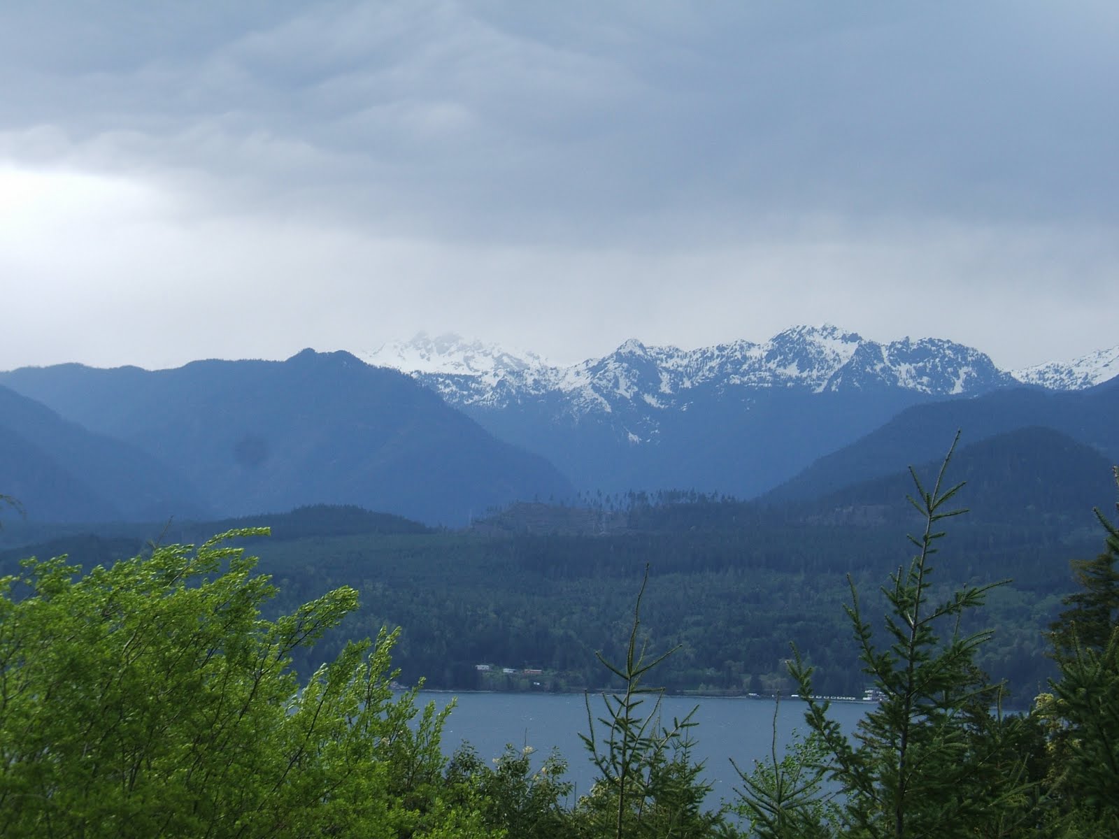
We are on Alaska time now, so we gained an hour. We are 4 hours behind home. We walked the deck and sat outside on life jacket containers. Slowly we moved into Bellingham Bay and then into the Strait of Georgia and past Vancouver Island. The weather is constantly changing from sun, showers, and mist Several barges being towed by little tugs pass us carrying piles of cargo containers. We are on our way to Alaska! We can hardly believe it’s really happening.

Being restless we walked to the ‘stern’ to check out the Solarium. This is where the younger folks hang out in tents rather than getting cabins. They were locking down the tents with duck tape! (It’s pretty windy) Many are sleeping in sleeping bags on the white plastic lounge chairs. (It’s good to be young…)

We had dinner. The food isn’t bad but a little pricy. Some folks brought their own Lean Cuisine dinners and sandwiches. After dinner we went up to the Bridge Deck to watch the movie - Avatar -

Later we went back outside for a while and enjoyed the views from the back of the ship. The light is fading to a dusky gray and the waters are calm as we sail up the strait with the Canadian shore line silhouetted against the sky. It’s amazing!

Time to call it a night.

Pictures: The Matanuska, Leaving Bellingham, Sailing Georges Strait, Islands in Georges Strait (2), Barge being pushed by tug, Tug boat.

Thursday, April 29, 2010

Fun in Fairhaven


This morning we are off to get our ferry tickets and then we’ll explore the historic Fairhaven district of Bellingham. We were amazed - there was no line at the ferry ticket window and we picked up the tickets and felt like we were on our way.

With tickets safely in hand we walked up the road to Fairhaven. The district sits on a hill above Harris Bay. It all began in 1853 when Daniel Jefferson Harris, 27 years old, set up camp on the beach where Fairhaven is today. He was a visionary and knew the place had potential. Beautiful brick buildings dating back to the late 19th and 20th century were built around the land boom of the 1800s. It was a raucous town and was as colorful as any in the gaslight West. Before heading to the Alaskan gold fields Mark Twain spent time in a Fairhaven billiard parlor. They thought the railroad was coming to town… it didn’t - it went to Seattle instead. In 1893 all construction in Fairhaven stopped. Today it bustles with life as people browse the shops, galleries, and cafes.

We roamed through little shops and found ourselves in a gallery where people were working on ceramic pieces. Walking through the store a staircase took us down into a small English Tea Room. We had lunch here and it was a really neat place. English lace curtains hung in the windows and an eclectic group of antique tables and chairs made you feel at home. We chose a table near the window looking out onto a little garden alley way. We ordered tea (which came in our own tea pots with cozies) and had a mixture of different tea sandwiches. It was really nice. After lunch we sat in the park for a while and I roamed through a nice old bookstore.

Later we went back to camp and started to get things ready for tomorrow. About 6pm we drove into Bellingham to D’Annas Italian Café for dinner. It was a cute little neighborhood place and very friendly.

Today was a really great way to celebrate our 21st wedding anniversary. Thanks to everyone who called and sent wishes. We couldn’t have had a better day!

Pictures: Alaska Marine Ferry Terminal, Tea Room, Ken lounged in the Fairhaven Park in front of mural

Wednesday, April 28, 2010

Mt Baker Wilderness


The morning started out cloudy but we are learning that by mid morning the clouds break up and the sun appears. A scenic drive was on tap today so down I5S to Lake Whatcom Blvd (Exit 253) which took us through forest and past lots of tree farms. The road led through little towns like Van Zandt and we followed the lake road along the edge of Lake Whatcom. It’s a typical lake community with nice homes lining the banks. Sudden Valley Golf Course came up on our right, but it’s too wet to play after all the rain we’ve had. The south end of the lake had a number of old camps and as we passed we could smell the smoke from the woodstoves.

We turned onto Rte 9 N toward the old logging town of Deming and home of the Nooksack Indian Tribe. The road passes several dairy farms and is very busy with cattle and logging trucks. The Stewart Mountains are on our left and there are patches of blue sky while the Twin Sister Range on our left is completely hidden in clouds. We had only planned to do a small part of this scenic drive, but it was so beautiful driving along the Nooksack River we decided to keep going.

At the junction of Rte 9 and the Mount Baker Highway (Rte 542) we turned right. The road wound in and out of sleepy settlements like Maple Fall with the sign “last gas” before entering the Mt. Baker Wilderness. The sunbeams were streaming through the thick trees as we rolled along. Soon we saw a sign for Nooksack Falls. Turning right down a gravel side road we could hear the cascading water before we saw it. We had the place to ourselves as we watched the river rush out of the forest, over smooth gigantic boulders and fall to the river below. This was one of the prettiest falls we’ve seen on our trip. At the bottom this cascade was joined by a second one and all of the water went crashing through the rocks into the river. The sound was thunderous.

Back on the road it became narrow and climbed switching back and forth. We watched the temperature go from 44 to 38 in minutes. We reached 3,000 feet and there was snow on the ground. It got deeper as we climbed further passing Goat Mountain (6,891 ft) and Mt Sefrit (7,191 ft). The views were spectacular. Continuing up we reached the Panorama Dome and Mt Baker Ski Area at 5,000 ft. Now it has started to snow and sleet so we decided it was time to head back down. It was like we had entered another world up here. On the way down we could see areas where snow had slid down the mountain due to melting.

On the way back we stopped at the Harvest Moon Bakery. It was just a little A frame, but the sign said New England Clam Chowder - hmm- lets see if it really is. We met a young girl in the parking lot from Vermont and talked as we walked to the bakery. She was going to school out here. Inside we ordered the chowder and went to sit in the sun outside on the deck. The owner asked where we were from and when we told him, he said he wanted our honest opinion…..ok. Well the chowder was great and he was happy.

Back at camp we relaxed and decided to go to Anthony’s on Bellingham Bay. Very nice restaurant, but I wouldn’t call it a relaxing place. The atmosphere was nice but the whole place seemed chaotic. However, the food was very good - great Halibut. After dinner we walked along the harbor and watched the sun set. It was another perfect day


Pictures: Nooksack River going to falls, Nooksack Falls, 2nd Falls, Road to Mt Baker Ski Area, Mt Baker 4000 ft, Road to the top, Mt Baker Slide Area, View of Goat Mountain, Harvest Moon Bakery, Sunset over Bellingham Bay

Tuesday, April 27, 2010

Beautiful Bellingham


Time to move north and catch up with Spring again! With a mix of sun and showers we turned onto Rte 12 E and then Rte 8 E which brought us to Interstate 5 North. It’s good to be on the road again! The Jeep seems easier to hookup and Ken doesn’t have to get down on his hands and knees anymore - that’s a good thing.

Riding towards Tacoma through the Nisqually Valley, Mt Rainier was to our right but we could only see a small piece sticking out of the clouds. Unfortunately Interstates are for fast travel and very busy with lots of trucks and traffic, but we’re moving along easily.

Soon we can see the Seattle skyline and the Space Needle in the distance. It looks like a really pretty city with a very picturesque harbor. The cruise ships will start coming here this week. We had planned to make Seattle a side trip, but hopefully we’ll get back someday.

Further north we can see part of the Cascade Mountains which are partially covered in clouds, but beautiful anyway. As we left the cities behind and entered the Skagit Valley we saw a hawk sitting on a fence post at the side of the highway just waiting for lunch to show up. The valley has a number of vineyards, fantastic mountain views, and is known for its tulip farms. One ranch sign read - “Tulip, Antiques, and Alpacas!” - they had it all. Continuing north we passed the first apple orchard we had seen. We thought we would see a lot more of these along the way as Washington is known for their apples. The highway skirts the Cascade foothills and runs between Lake Samish and Lake Whatcom and the wind has picked up quite a bit. As we enter Bellingham the road is lined with blooming trees and rock walls and is very pretty. As the southwest identifies with Santa Fe, Bellingham is the essence of what the Pacific Northwest is all about. It’s a great place to spend time filled with cafes, bookstores and beautiful parks. We found our campground and got settled in. The campground is nice and the folks in the office suggested some nice restaurants which we will try later.

Off to the find the Alaska Marine Ferry Terminal to pick up our tickets - oops cut backs have hit here too. They were open yesterday and won’t be open again until Thursday. Guess we just have to wait. Across from the terminal was a little park so we went to investigate. It had pretty gardens and benches right on Harris Bay where we could see the pleasure boats docked in the harbor.

We picked up some veggies for dinner and went home. I can’t believe we get on the ferry in 2 days!

Pictures: Marine Park

Monday, April 26, 2010

The Challenge

We hopped in the Jeep and drove to Tacoma this morning. At 8:45am we were parked in the lot at 4 Wheel Parts waiting for them to open. They took the Jeep right away and started installing the rack. While we waiting we walked down the street to explore. We visited a Pawn Shop (we'd never been in one before) but didn't find anything exciting. The rack was ready about noon and it looks really nice. Now we have to see if the cartop will fit on it....

Arriving back at camp and ready to load... here comes the rain! So we donned our new rain jackets and headed for the storage shed. This is the challenge. We emptied the contents of the carrier and were about to try and hoist it onto the top of the rack (I'm now standing on a step stool ) when one of the men in the park stopped by and helped Ken lift the carrier onto the rack (whew). Ok we got it positioned, but the rack rails are a 'little' fat and the closures don't go all the way around! Ken says they are just fine....ok....

Next was the biggy! With the RV spare tire positioned in the middle of the back we lifted, twisted, and pushed the boat into the back along with it's accessory bag. They now sit on top of the tire (I don't know if we'll ever get them out!). We 'high fived' to celebrate!

We spent the rest of the day getting ready to move out tomorrow finally! We stayed in and watched TV. Thank goodness we were able to pack things, now lets hope the top stays on the Jeep! Ken says it's just fine ....

Sunday, April 25, 2010

History At The Rusty Tractor


Breakfast today at the Rusty Tractor - the hot local spot! We learned at breakfast that Elma's claim to fame is a 1914 bank robbery. The robbers took $2,300, but left $7500 on the cashiers desk.... they were captured and not a shot was fired!

With our history lesson over for the day there were more backroads calling so down Main St we went (Rte 108). The little towns here have great names. We turned onto Monte-Elma Rd and rolled through the town of Satsop. Fishing opened yesterday but we haven't seen anyone in the rivers yet. We pass lots of nurseries and bulb farms.

Winding along the Satsop River on Middle Satsop Road we turn left onto W Boundary Rd. The landscape is turning to a mix of forest and then pastures as we reach Cougar Smith Road which was paved but soon turns into a gravel logging road. Fortunately there are no logging trucks or traffic because it's Sunday. The forest gets thicker as we cross the bridge over the Wynoochee River. The gravel road now becomes National Forest Road #22 and we followed it to the Wynoochee Dam and then into the Olympic National Forest with openings that give us great mountain views.

To our left was a dirt path so we took it deeper into the forest. Heavy logging is going on in this area. There wasn't much to see so we retraced our route back to the main road. Soon we came to the Wynoochee Lake area with lush ground cover that looks like carpet under the Douglas Fir & Spruce. Unfortunately we came to a gate. The rest of the road was closed for wildlife habitat enhancement until May 1. We sat on the side of the road by the gate listening to the sounds of nature when a high pitch sound came from the woods like a sharp whistle. We listened for a few minutes, to try and figure out what it was. The call came one more time, but we couldn't see anything. Down the road we parked in a pull off next to the river and followed a path for a way. There were lots of big tracks that were fairly recent - we weren't sure what they were. The sound and the prints could have been Elk. After a while we returned along the river to the car.

We turned back and took a road we had seen on the right which led towards the dam. The dam is a very old metal dam which is badly rusted. Continuing up the road we came to another "closed" gate so we decided to pull over for a snack. We are in the rainforest part of the Olympic National Forest now. The temperature and air has changed since we left the dam. This area looks like it constantly rains.

We turned onto Forest Rd #2220 and followed it back to Rte 101 and then followed backroads home through the Wenatchee Valley with towns like Brady and Montesano. Montesano is a charming 150 year old town which became the county seat for Grays County in 1860. It lines it's Main St with Japanese Cherry trees and as we drive through they are all in bloom. It was beautiful. We've put on over 1000 miles since we got the Jeep 9 days ago.

Joseppi's Pizza was our dinner stop tonight. We watched TV and called it a day.

Tomorrow we have to deal with the rack and pack the Jeep. The boat will fit even if I have to buy a Sawzall!

Pictures: (right to left) The Rusty Tractor, Forest Road 22, Wynoochee River (2)

Saturday, April 24, 2010

Getting Ready To Go

Today was a mixed bag, sun, showers, sun, heavy rain...etc. It was a good day to stay in camp and get things ready for the next leg of the trip. Later in the afternoon and in between showers Ken went for a walk and came back about 2ish.

About dinner time we noticed a faint rainbow over the campground. It's the first one this trip. We had planned to go to the auto races tonight, but they had to cancel because of the rain. Believe it or not Elma offers many tpes of recreation and it is the home of Grays Harbor County Fairgrounds which brings auto racing to town every year. We took the rainbow as a good omen and decided to check out the Lucky Eagle Casino to replace the races. The eagle wasn't so lucky and we headed home.

We watched TV and went to bed.


.

Friday, April 23, 2010

Kitsap Adventure


An adventure to Kitsap Peninsula in Puget Sound is on the docket today. Just before we left Ken's phone rang - great news... the rack is in and we'll get it installed on Monday. We are back on track sort of. We can leave Elma on Tuesday for Bellingham.

Driving happily up 108 E to 101N to Shelton through the spring countryside with tons of yellow flowers along the road every where. We turn onto Rte 3 that will take us to the heart of Kitsap Peninsula. Rte 3 runs along a ridge looking down into little inlets and channels. We stopped at the Sunny Day expresso stand. Washingtonians love their coffee and there are these little expresso stands all over the place.

Our next turn takes us onto Rte 302 E down a woodsy incline past beautiful cottages and homes along Case Inlet. The gardens here are full of dogwood, azaleas, and rhoddys. Soon we turned again toward Vaughn to take the little road to Key Peninsula in Longbranch. We explored great little villages and towns like Home and stopped at a state park at the end of the peninsula. We are seeing fresh produce stands now with Asparagus and fresh Corn, and we wondered where it was coming from.
Turning onto Rte 16E we point the Jeep towards Gig Harbor. This is a picturesque harbor resort community on the Hood Canal. We walked north through town and window shopped the upscale galleries along Main St. We found the Tides Tavern right on the canal. From our window seat we watched the sailboats and leisure boats pass by. We marvelled at the lavish homes across the canal with fantastic tiered gardens and long staircases that reached to the water. After a nice lunch we strolled down to the pier and looked at the pleasure boats.
Continuing up Rte 16E to Bremerton we saw our 1st view of Mt. Rainier between the clouds, as a backdrop to Puget Sound. Bremerton is a big ferry town for folks coming from Seattle. We watched a ferry cross the sound and then headed north on Rte 3 to a little village called Seabeck. Out of Seabeck we took one of those "little black roads " on the map which led us along the Hood Canal. We could see the Olympic Range covered in fresh snow in front of us in the distance. We stopped at Big Beef Creek which runs into the canal and then ambled further along the road. The canal here is mostly obscured by trees, but there were great mountain views. Each turn gets better and better. Riding down Dewatt Rd we stopped on a ridge and then soon found ourselves back in the forest. We are now heading for the town of Union...we thought. We were ignoring Adora (our GPS) because we thought she was trying to take us back to Rte 101 and we thought our little back road connected to it also. Heading to Union, we thought, we followed Windy Rd along the canal to a neat looking cabin out on a point of land. Unfortunately a "private property" sign stopped us. Continuing to the town of Tahuya (fun to say) the wind suddenly came up and was whipping the canal into white caps. Following the twisty Northshore Rd we found there was no way across the canal---- so we retraced our steps and followed the road to Belfair to pick up Rte 106 and eventually Rte 101 (Adora was right). Gorgeous trees and gardens line the road and give privacy to the homes along the canal and makes a great ride. Brilliant colors of vivid red rhoddys, pink and white dogwoods and daffodils. These are also the roads to drive if you want to know where the locals eat - like Pats Little Rd Barn which was packed. We finally found Rte 106 and took the Purdy Cutoff Road to 101 and then Rte 108 to camp.


We did about 250 miles today on our little adventure. It was too long a ride for a side trip.

Pictures: Gig Harbor, Big Beef Creek (2), Dewatt Ridge Mountain View (2)

Thursday, April 22, 2010

Entertaining Our Neighbors

Off to Centralia this morning to do "problem resolution". It's a pretty day and we had breakfast outside while we decided what problem to resolve today! We measured the Jeep's back seat and then went to find a box we can pack it in to ship home. Ken found a Uhaul office and they have a large wardrobe box that we think will fit the seat. Getting the box was no big deal - getting it into the back of the Jeep was interesting.... We shoved it through the back and up over our heads and off we went back to camp.

People have been really helpful here and we learned the US Post Office would ship our box if it was 70 lbs and 108 inches in girth and length. Ok, now it's time to do some packaging... Getting the seat out of the Jeep was easy. Now we had to figure out how much it weighed. Ken had noticed a bathroom scale in the club house so we drove over and he brought the scale out to the parking lot. We balanced the seat on the scale (oh ya the scale was missing a foot) so we thought the seat weighed 70 lbs. Hmm how much over will the box make us?
Oh by the way, everyone in the park is wondering what in the world these wacky people from New Hampshire are doing.... Back at the picnic table we slid the seat into the box and proceeded to cut and tape the box like patch work to make it fit the post office demensions. We hoped by cutting the box down we had trimmed the weight enough... Off to the post office and put it on the scale - yep a whopping 73 lbs. Nope they couldn't ship it... so we put it back in the Jeep. The guy in the post office told us where the UPS office was so off we went. Ken put the box on a dolly and took it in (I locked the doors, that box was not coming back!). Yea they took it and for less than the post office.

We went back to camp, celebrated, watched TV and then went to bed.

Wednesday, April 21, 2010

The Power of Nature


Today we are forgetting about all our hassles and taking a ride to Mount St Helens. I5 S is very commercial and we’re glad when we turn onto Rte 505 E rolling through fields with blooming apple trees and dogwood. Toledo is the gateway to Mt St. Helen. There are lots of Christmas tree farms along the road. We are seeing a lot of "Slide Area" signs along the road. We can see where they've done winter clean up and rock removal. Turning onto Rte 504 we climb through thick forest. We’re back up in the tree tops again riding along a ridge.

The Hoffstadt Visitor Center appeared on our right and we pulled in. Entering the center through huge wood doors we’re met with a gorgeous panoramic view of the Cowlitz Valley which is still covered in lava from the blast. We spent time on the viewing deck and followed the trail which led to a memorial grove dedicated to the victims of the eruption.

Continuing up the road we came to the Mt St. Helen bridge which leads across the Hoffstadt Bluffs Creek and into the "blast zone". We stood at the end of the bridge looking across at the edge of the "blast zone" with the volcano in the distance. We could see standing dead forest - trees that were unable to burn due to the lack of oxygen during the blast. We tried to imagine what it was like that day - A 5.1 magnitude earthquake shook Mount St. Helens at 8:32am on May 18, 1980 triggering a massive explosion. The mountain blew 60,000 feet of heated ash into the cloudless blue sky. The steam and pressure under the volcano resulted in 1300 feet of the mountain’s top to launch outward. The cataclysmic blast - carrying winds reaching 670 miles per hour and temperatures of 800 degrees F - flattened 230 square miles of forest. Elk, deer, and other wildlife were obliterated.

We stopped again at Coldwater Ridge Visitor Center and tried to see the crater through the clouds. We watched a video about the days leading up to the blast and what happened. A sign on the center door told us the road was closed 9 miles up the road due to snow and winter conditions. We continued up the road climbing to 3000 feet along the Coldwater Ridge until we found snow. Soon we were completely socked in. With snow covered roads and no visibility we turned around after playing in the snow. Maybe we'll stop by this way when we come out of Alaska.

Meandering back down Rte 504 our next stop was the Mt. St. Helen Memorial Visitor Center. We watched another film on volcanic activity and saw exhibits of photos, ash and debris. We learned more about that day and about Harry Truman. Harry owned the lodge at Spirit Lake. Harry refused to be evacuated. His late wife was buried at the lake and he didn't believe the volcano would blow. When the blast came the strength was unimaginable. The entire lake and it’s contents were sent 600 feet into the air before it fell back to earth. The lake is now twice the original surface area and half its original depth.

Leaving the center we walked the nature trail through a marsh around the visitor center with views of the volcano. The clouds over Mt. St. Helen are starting to lift, but we still can't see the top. This is a very powerful place and reminds us what lies beneath our feet.

It was a lot of driving today, but it was spectacular - we will come back again.

Pictures: Lava in Cowlitz Valley today, Mount St. Helen Bridge, Volcano view, Snow play, Road down from Coldwater Ridge, Visitor Center trail

Tuesday, April 20, 2010

Stalled In Elma

While we waited to hear news on the rack we decided to run some errands as we are stuck here! We drove to Chehalis and found a shopping mall. Then we got the call….

The manufacturer says they can’t get the rack to us until 4/28 because they need to build it and then ship it by truck from Canada…Wrong, Ken told them they needed to find one and send it overnight.

Now we are in negotiations - Ken asked them if they had ever heard of DHL????
To make a long story short they baulked at the overnight delivery, but in the long run they said they would look into it.

Another day to wait…..

Monday, April 19, 2010

Jeep Saga

This will be short…. We spent the day at Brazel Precision to get the base plate installed on the Jeep. We had to be there at 8am and we spent the whole day in the waiting room. The base plate allows us to connect the car to the coach so we can tow it.

While we were there it was time for Ken to follow up on the rack for the Jeep….. and soon the day went to ... oh well...

  • First the shop installing the rack said it was in the distribution center in California - Ken said why, you have a center in Washington - they didn’t know why and said they would check and call back…
  • No news at 2pm so we called - the order in CA wasn’t ours and come to find out ours was never ordered!
  • Today is the 19th and we were promised it would be installed on the 21st…

Seeing we bought the Jeep based on their promise we were not happy - they knew about our time deadlines and had agreed to get us the rack. Now they want to cancel the order, Ken said no …. so we got - we’ll see what we can do and call you back.


Needless to say we are nervous as we need to be on the ferry to Alaska on 4/30 and have to have the rack on by 4/27 at the latest…

We are trying to stay positive.

Sunday, April 18, 2010

Taking A Break

Just a day at camp. The weather today was great and in the 60’s. We hung out at camp today - laundry, packed small things into the Jeep. I worked on the blog, Ken read and we sat outside for a while.

Later we went to the Lucky Creek Casino for the buffet. They had a lot of really good seafood. Ken had several plates of ‘steamed clams’ and said they were good. We tried fresh fried oysters for the first time and they weren’t bad either. We played for a while and then drove home….

We needed a relaxing day like this.

Saturday, April 17, 2010

Jeep-saw Puzzle

Today our plan was to arrange the Jeep. All of the “stuff” that was in the HHR is now in the front cab of the RV. The boat, boat accessory bag, spare RV tire and car top carrier is still in the storage shed they loaned us. During a let up in the rain we planned, measured, and tried several options to see how we might get the boat in. I think we found a way - hmmmm. However, now we have to figure out whether we take the back seat out of the Jeep
 
We went to pick up supplies and had lunch in Elma. This is a really friendly community, which was established in the 1860’s as a trading center for settlers in the Chehalis River Valley. Downtown, two-dozen historic murals bring buildings to life. They depict the colorful history of the community and its logging heritage. One of the best murals portrays Main Street in 1900.

Tonight is Meatloaf Dinner night at the park for $5 so of course we’re going (I love meatloaf). Around 5pm we mosey’d over to the club house. It’s a cozy redwood building with fieldstone fireplace, nice kitchen, big screen TV, and comfy chairs. They have games and a lending/exchange library. We picked a table and joined another couple. Come to find out their daughter lives in Goffstown, NH - not far from us. it’s a small world! Dinner was great and had all the fixing’s including desert.

Later we watched TV. It was a busy day….

Friday, April 16, 2010

Meet The Jeep


Today is a big day - we say goodbye to the HHR and hello to our new Jeep! To bring you quickly up to date we legally bought the Jeep on March 27, but didn’t take possession until today for several reasons…try buying a vehicle from across the country! To make this a short story -
  • the car was in Salem, Oregon and needed to be brought to our dealer in Coos Bay

  • We had to get the title sent from home to us - thanks to our son Mike for getting this and having it sent to our dealer who acted as our post office

  • We had to register the new vehicle in NH and roll over the license plates - thanks to our friend Bob for taking our paperwork to the town office and mailing back the new paperwork

  • The dealer prepared the Jeep so we could tow it behind the RV

  • Ken had to find a rack that would fit the Jeep and hold the car top carrier - took him a week but found one - but they were back ordered and they promised us they could get it for us in 3 weeks…. Close but doable

  • Needed a base plate for the Jeep so we can tow the vehicle


Meanwhile we were continuing our trip during all this time and had to find a place where we could do the car exchange… With all the paperwork in hand and the car ready our salesman (Mike Johnson) agreed to meet us half way between Elma, WA and Coos Bay, Oregon - so we agreed on a truck stop off I5 in Salem, Oregon….


You probably all think we are crazy by now. We had a great car and everything fit in it nicely - now we’ll have a Jeep that still needs a rack to put the car top carrier on and we’re not sure the boat will fit….Ken assures me it will work… ok…


Down Rte 12 passing through woods and farmlands on our way to Salem, Oregon 3 hours away. We connected to I5S in Centralia, Washington and followed it all the way. We saw Mt Rainier in the distance covered in snow and clouds. It was very majestic. We’ll be visiting the National Park later in our trip. We also caught a glimpse of Mt. St. Helens which looked peaceful… at the moment! The highway winds along the Columbia River through Washington to Oregon. Around the Kalama, WA area we saw pilings initially used to tie up rafts of logs and barge boats during the timber boom. Now the pilings act as nesting places and we saw several Osprey in the nests. We didn’t realize there was a bypass around Portland and Vancouver until it was too late so we ended up going through both cities - Yuk - we crossed a huge bridge taking us over the Columbia River and into Oregon and the traffic was awful. We found our way to the truck stop and waited for Mike to arrive.

We made the switch easily and immediately headed back to Elma. The Jeep is nice, we’ll miss the HHR, and it will be fun. I just hope everything fits! Well this is one thing off Ken’s Bucket List - I didn’t know he always wanted a Jeep.


Back in Elma at 10:30 - we’re tired so off to bed.

Thursday, April 15, 2010

Grays Harbor History


Today we'll do a loop around the south side of Gray's Harbor. We did the North loop a week or so ago when we were in Copalis Beach. Rte 12 W took us through woods and small communities. There are many interesting communities forming this coastal area. The first residents were the Chehalis and Chinook Indians.

We turned onto Rte 107 which ambles along the Chehalis River. The river is fairly high and we haven't seen anyone fishing. Ken saw a little place called Clarks so we stopped for a late breakfast. It was a cozy little log cabin type building with old pictures of the area on the walls and run by a family. After breakfast we continued down Rte 107 to Rte 101 S and rolled through the town of Raymond and turn onto Rte 105W toward Tokeland Peninsula.

Our Washington Planner Book (these are fantastic) told us not to miss the historic Tokeland Hotel, the oldest resort hotel in Washington. We drove out to the end of the road where there was a fish processing building and then stopped at the hotel. It's a lovely old style farmhouse with a very homey feel and was built in 1885 as the home of William S. Kindred and the daughter of the homesteader, Elizabeth Brown. Five years later they expanded their farmhouse and opened the Kindred Inn. Two steamers, Shamrock and Reliable, made trips from South Bend to Tokeland. Mr. Kindred used to meet the boats with a big, horse-drawn carriage. Tokeland soon gained a reputation as a fine beach resort, attracting guests from as far away as Idaho and southern California. Today the hosts are keeping the same tradition by offering comfy rooms and good home style food.

There isn't much else in Tokeland, so back up Rte 105 W through little beach villages. North Cove and Grayland had many accesses to the beach, so we drove the car onto the beach, but it was a little mucky after the rain so we left.

Up the road to Westport at the end of another peninsula which sticks out into Grays Harbor. There is a summer ferry that takes you across to Ocean Shores where we were a few days ago. We followed the signs for Grays Harbor Lighthouse which is still an active aid to navigation today. Up the road from the lighthouse we found a 1.5 mile paved trail along the the dunes. We walked the trail which we found to be a memorial to people lost at sea and others who loved the ocean. We sat on one of the benches and just appreciated what was around us. At the end of the trail was a jetty where we saw guys surfing and we watched for a while. Following a path down the dunes we walked back on the beach looking for sand dollars and agates. Ken loves roaming the beaches. The tide was starting to come in so we decided to climb up the embankment and sat on the edge of a dune watching people on the beach. Then we took the trail back to the car.

Driving around the rest of Westport we saw fishing shacks and a little marina with lots of boats that look like they've had a hard life. We liked the one that was named - "HARD WORK"!

Following Rte 105 along the harbor and onto Rte 12E we headed back to Elma. It was a nice day. We had grilled hot dogs and hamburger outside tonight and enjoyed the warmer weather. It was in the 60's today.

Pictures: Westport beach, Westport walking trail

Wednesday, April 14, 2010

Gems Along the Canal

A perfect Sequim day, sunny with big puffy clouds. Down 101 and soon we entered the Hood Canal Watershed. This whole area is loaded with recreation opportunities beaches, boating, fishing, hiking - definitely something for everyone. Passing through Quilcene a gas station, oyster store and liquor store makes up the hamlet. We stopped for breakfast at Loggers Landing and sat right next to the window with hummingbird feeders where we watched the Anna come and go. Continuing on, the clouds have risen above the mountains and we can see the snow in the Olympic National Forest as we climb over hills and pass Mt Walker. Rolling down a grade we round a curve to an "Ah" view - our first of the Hood Canal.

The Hood Canal is not really a canal but a 63 mile long, 600-foot deep body of calm water that is a saltwater fjord carved by glaciers. This region is well known for it's clams and oysters. We crossed the sparkly Dosewallips River with summer homes and docks lining the water way and watched people clamming in the mud flats. We passed through little villages with great names like Duckbush, Hamma Hamma, Lillawarp, and Hoodsport. This is a place where even the old time drive-in movie theatres are still alive on weekends!

We turned onto State Route 108 leading through the lush Chehalis River Valley and then turned onto Rte 8W heading back towards Aberdeen. We just completed the whole Olympic loop and it was fabulous!

We arrived in Elma, Washington and found the Travel Inn Park. This is a great little park and has fairly new facilities. This is our staging point to get ready for the ferry and heading to Alaska. The owner gave us storage space and we unpacked the car and took off the cartop carrier. Thank goodness for the storage now we don't have to leave our stuff outdoors.

We went to check out downtown Elma. First impression is a nice little town with cute older homes, great gardens and a new high school. They've refurbished a lot of the older stores and it offers all the necessary basics - groceries, coffee shop, and pizza. Naturally there's a chineese restaurant and we had dinner there. The other thing we noticed is there are a lot of churches. We came to one intersection where there was a church on each corner.

Back at camp we watched TV and called it a day.

Tuesday, April 13, 2010

A Strollable Seaport


Off to explore Port Townsend today in the northeast corner of the Olympic Peninsula. The character of today comes from it’s boom in the 1880’s and 90’s when it was a major seaport for fishing and timber. They have kept the old stone buildings and magnificent Victorian homes which give this strollable seaport it’s old time charm.

We parked on main street and walked past old preserved brick warehouses that act as shops, galleries and restaurants today. Wandering onto the pier at Admiralty Inlet we read the historical markers where steamers and traders arrived in the 1800’s. There’s plenty of history to absorb here.

Across the pier we watched them load the ferry boat that was going over to the Kitsap Peninsular across the Puget Sound. Exploring a side street we found the Silverwater Café and stopped for lunch. Then we continued our walk through the tree lined streets of town.

We drove up the steep hill to the “uptown area” overlooking Admiralty Inlet. Driving around the “uptown area” revealed several spectacular Victorian homes built between 1860 and 1900. Many of these are private but a few have been turned into B&B’s. The “uptown area” sits high on a cliff overlooking the wharf and main street. The sun has come out and the views are spectacular. Port Townsend is one of only three remaining Victorian seaports in the country and was designated a National Historic Landmark District in 1976.

Leaving Port Townsend we headed back to camp. As we were having dinner Ken looked out the window to see a Blacktail Deer standing right next to our door eating dandelions. They are beautiful, but they are loosing their winter coats and they look like patchwork.

We watched TV and then off to bed to prepare for another day….
Pictures: Victorian homes (2), Port Townsend Main Street

Monday, April 12, 2010

A Silent Sanctuary


Off to the Olympic National Park Visitor Center in Port Angeles this morning to get information on Hurricane Ridge Road, so we can hike the Meadow Loop Trail. The trail provides visitors with terrific views of the Olympic peaks especially Mt Olympus at 7,965 feet. You can’t drive to Mt Olympus, the only way to see it is from a hiking trail or park road vantage point. Unfortunately there is still too much snow on Hurricane Ridge and the road is closed. We watched a film on the park which was fantastic called Mosaic of Diversity.

The ranger suggested we take a ride through the Elwa River Valley so we did. We drove Rte 101 to Olympic Hot Springs Rd near the Elwa River. There are 168 miles of roads that give you access to various points in the park. Most of the roads are closed in winter and 99 miles of the roads are pretty good gravel (our kind of road). All park roads are “spur roads” which come off of Rte 101 and none of them go across the entire park. The road twisted and turned through the tranquil valley as we followed it to the end. On the way we saw lots of deer grazing along the road. They are beautiful animals and not afraid, we‘re just an aggravation. We stopped at the observation point at the end of the road and took the West Lake Mills trail along the river. The trail was beautiful and we startled a few deer as we clomped along the trail. We had fun playing Robin Hood and Little John with our walking sticks as we crossed a log bridge (both being careful not to fall in). We sat along the river on a rock for a while listening to the quiet wilderness. After about a mile the trail turned deeper into the forest so we decided to go back to the car.

On our way back we took a side road and parked at the Madison Falls trailhead. We could hear the water roaring as we walked the short trail. It was a pretty waterfall and the water was really flowing for a change!

Leaving the valley we took Rte 101 to the turn off for the Log Cabin Resort on the north end of Lake Crescent. The resort was closed but the views of the turquoise lake were gorgeous. The road looked like it ended, but there was a spur road off to the right so twisting along this old logging road we found ourselves in the small town of Joyce on Rte 112. Rte 112 took us back to our favorite Rte 101 and now we’ve traveled almost all of the roads along the northern coast of Washington!

On our back through Port Angeles we stopped at the wharf area and saw ships waiting to be loaded with products. The docks were filled with huge cargo containers all piled on top of one another. Then we headed back to camp. You can’t describe the beauty here and the wilderness is breathtaking but scary too!
We decided to follow Diamond Point Road to the end to see Sequim Bay. The road took us through a residential area and we wound our way around corners and down a steep hill. Coming around a corner there were deer everywhere. These folks have apple trees galor in their yards which bring the deer. After weaving through the wildlife we stopped at a view point overlooking the bay.

Tonight we’ll visit the 7 Cedars Casino up the street. Many of these casinos have great history attached to them and are decorated with totems and designed similar to clan houses. 7 Cedars represents the S’Klallam Tribe. Resisting pressure to move from their tribal land to a reservation Lord James Balch led several communities in 1874 to combine their resources and bought 210 acres of land north of Sequim called Jamestown Beach. In 1981 the tribe achieved federal recognition. Their casino offers fine dining, big name entertainment, a gift shop with Native American art and of course the usual games.

It was a good day…..

Pictures: Lake Crescent Rd, Lake Crescent, Elwa River, West Lake Mill Trail, Madison Falls, Diamond Point Deer, 7 Cedars Casino